Location
6184 Wilson Boulevard Arlington, VA 22205
38° 52.358′ N 77° 8.754′ W
Historical Designations
All Boundary Stones (incl. SW8) located in Virginia were added to the National Register of Historic Places in February 1991.
Historical Significance
The boundary stones are the oldest federal monuments. The Residence Act of July 16, 1790, as amended March 3, 1791, authorized President George Washington to select a 100-square-mile site for the national capital on the Potomac River between Alexandria, Virginia, and Williamsport, Maryland. President Washington selected the southernmost location within these limits, so that the capital would include all of present-day Old Town Alexandria, then one of the four busiest ports in the country. Acting on instructions from Secretary of State Thomas Jefferson, Major Andrew Ellicott began surveying the ten-mile square on February 12, 1791.
In 1915 the District of Columbia Chapters adopted the Boundary Stones, acquired deeds from the property owners to install a footing for the iron protective fences. The DAR had identical fences designed and installed around the stones and in 1916 dedication ceremonies took place to mark the stones with a plaque with the name of the Chapter who agreed to be its steward. (Wording from www.boundarystones.org).
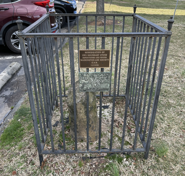
The last boundary stone to be fenced and dedicated was Southwest Boundary Stone 8 (SW8), located at Upton Hill at the highest point of the 40-mile square. In 1949, Dr. Elisha Dick Chapter, NSDAR, agreed to accept stewardship for SW8 and on December 5, 1950, the chapter held a dedication ceremony at Upton Hill for the last of the original boundary stones of the District of Columbia, placed in 1791, and protected it with a green iron fence.
In February 1991, all of the boundary stones located in Virginia were added to the National Register of Historic Places at the request of the Virginia DAR. In the late 1990s, SW8 was moved to the Arlington County Courthouse basement for safekeeping during construction. On November 11, 2000, SW8 was repositioned and fenced by Washington-Lee Society, C.A.R., with support from Dr. Elisha Dick Chapter, NSDAR.
The stone is located along the driveway into the Patrick Henry Apartments from Wilson Boulevard, just east of its intersection with John Marshall Drive and N. McKinley Road, at the edge of the parking lot, about 100 feet southeast of a water tower.
Marker Details
1950 and 2000, Dr. Elisha Dick Chapter, NSDAR
1950 plaque reads:
Original Federal
Boundary Stone
District of Columbia
Placed 1791-1792
Protected by
Dr. Elisha Dick Chapter
DAR
1950
2000 Plaque reads:
Rededication of
SW8 Boundary Stone
Repositioned and Fenced
Washington-Lee Society
C.A.R.
11/19/00